Sherrelwood Town Hall Snapshot
Geographic Summary:
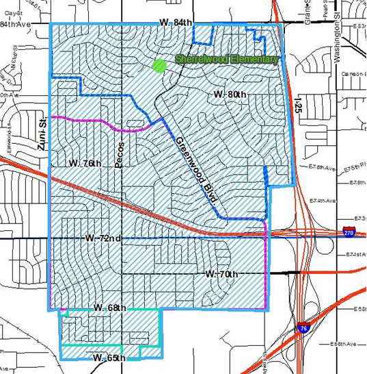
- Area is roughly bounded by Zuni Street on the west, E. 84th Avenue on the north, I-25 on the east, and 66th/65th Avenue on the south
- Approximately 3.1 sq. miles; 2,034 acres
- Approximately 23,000 residents (2010 Census)
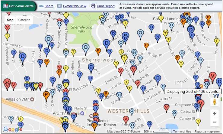
Neighborhood Crime and Traffic Incidents
Area Demographics
Sherrelwood Elementary School demographics
- White 13.1%
- Hispanic 81.4%
- Asian 1.4%
- Black 1.4%
- Pacific Islander 1.4%
- Eligible for free lunch 75.6%
- Eligible for reduced lunch 17.9%
Source: Startclass.com
Area Income Information (estimates)
Median household income for block groups ranges from $23,154 to $62,083 annually
- Median household income: $45,103 ($57,421 countywide)
- Median family income: $44,006
- Median per capita income: $19,172
- Percent of households under the poverty line: 18.6% (for 2016, this is $24,300 for a family of 4)
Race (2010 Census)
- White, not Hispanic 34.8%
- Hispanic 33.7%
- Hispanic/Latino (summary, includes all races and Hispanic/Latino) 59.1%
- Black 1.3%
- Native American 2%
- Asian 3%
- Hawaiian/Pacific Islander 0.2%
- 2+ Races 3.8%
- Other 21.1%
Education
- Less than high school degree 30.65%
- High school degree 35.3%
- Associates/Bachelors 11%
- Advanced Degree 2.6%
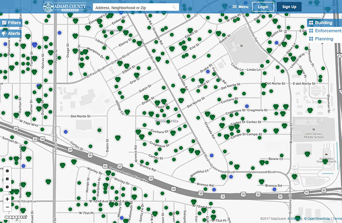
Code Enforcement and Building Permits
Look up code enforcement violations and building permit applications through our interactive tool Eye on Adams:
Land Use Cases: For current land use cases, visit the county's Community Economic and Development's Land Use Case site.
Oil and Gas Information: For weekly activity reports, current oil and gas cases, frequently asked questions, and more information, visit the Community Economic and Development Oil and Gas site.
Marijuana Information: There are no marijuana businesses within the identifed area. For more information on marijuana licensing in unincorporated Adams County, visit our Marijuana Licensing page.
Parks and Open Space
-
In this area you have Twin Lakes Park. A large renovation is hoping to begin the Fall of 2017.
-
Parks has just completed public comment and the project is currently in design. Along with this project, the Parks department will be looking at some drainage issues that has created a mosquito problem. They are currently working at trying to solve the drainage issues without losing the trees on the property.
-
-
The Clear Creek Trail next to Midtown received some flooding damage. This trail is set to receive a replacement trail to repair the flood damage.
-
Clear Creek Bottomlands: Parks has been actively working on removing noxious weeds (primarily Russian olive trees) from this area.
-
Notes: This area is surrounded by Hyland Hills and Westminster. Thus there may be additional public comment on what these jurisdictions are doing in the area.
Topics of Potential Discussion
- FasTracks: The Westminster station opened July 25, 2016
- Gold Line: Pecos and Federal Stations opening in 2016
- Marijuana locations:
- Starbuds 1451 Cortez Street
- The Green Solution, LLC 6681 Federal Blvd. (a bit outside of boundaries)
Transportation
Presently, no complaints/needs cited in YourGov.
Current improvements:
- Lowell Blvd. between 56th to 62nd currently in design (widening, curb/gutter/sidewalk, storm sewer systems, and retaining walls as needed; the project will begin next year).
- NW 60th realignment: Realignment constructing a new intersection at Federal Blvd. and W. 60th Avenue to provide access for Federal Station. This is presently in construction (federally funded).
- W 56th Ave. Improvements (Federal to Zuni): Currently in construction; includes bicycle and multimodal improvements.
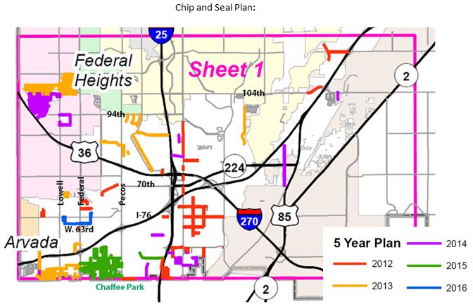
- Chip and Seal (2016): W. 63rd Avenue (South of 64th, including Julian and Clay Streets).